DjangoAdminGeomap library
The free, open-source DjangoAdminGeomap library is designed to display objects on the map in the Django views and admin site.
There is a full-fledged multifunctional GIS framework GeoDjango.
When is used in the Django admin site, you can display objects on the map.
However, GeoDjango has a large list of dependencies on various libraries
and the specifics of installing these libraries on various platforms.
If you only need to display objects on the map in the Django admin site, then you can use the DjangoAdminGeomap library.
It has no additional requirements for the names and data types of fields in the database tables, and there are no installation dependencies.
DjangoAdminGeomap uses the OpenLayers JavaScript framework to display map data.
The source of the cartographic data is the data of the OpenStreetMap project.
Installation
pip install django-admin-geomap
After installation, you need to plug the library into your Django project by making changes to the settings.py file.
Changes to settings.py
To connect DjangoAdminGeomap to your project, you need to add to the file settings.py in the key TEMPLATES the path to the directory templates of the library.
TEMPLATES = [
  {
    'DIRS': ['path/to/installed/django_admin_geomap/templates'],
  },
]
An example of such a connection can be found in the file example/settings.py.
It is not necessary to include the library in the INSTALLED_APPS list in settings.py.
Initial data
Let's say we have a table in the database, the records of which contain data about coordinates.
# models.py
from django.db import models

class Location(models.Model):
    name = models.CharField(max_length=100)
    lon = models.FloatField()  # longitude
    lat = models.FloatField()  # latitude
On the main page of the site and when working with this table in the admin panel, we want to see a map with objects from this table located on it.
Main page with a list of objects on the map
To enable the display of Location objects on the map, you need to make changes to the model class in the models.py file.
Add the django_admin_geomap.GeoItem "mixin" class to the inheritance list of the Location class and define two properties: geomap_longitude and geomap_latitude.
These properties should return the longitude and latitude of the object as a string.
# models.py
from django.db import models
from django_admin_geomap import GeoItem

class Location(models.Model, GeoItem):

    @property
    def geomap_longitude(self):
        return '' if self.lon is None else str(self.lon)

    @property
    def geomap_latitude(self):
        return '' if self.lon is None else str(self.lat)
After making these changes to the definition of the model, you can display a map with objects from the Location table in an arbitrary view.
To do this, you need to include the file geomap/common.html in the page template. For example, the site root page template home.html might look like this:
<!DOCTYPE html>
<html lang="en">

<head>
<title>DjangoAdminGeomap example</title>
</head>

<body>
Hello, OpenStreetMap!
<div>{% include "geomap/common.html" %}</div>
</body>

</html>
In the view function, you need to pass to this template the context formed by calling the geomap_context function.
As a required argument to the function, you need to pass an iterable sequence of objects to display on the map.
For example a list or Django QuerySet.
# views.py
from django.shortcuts import render
from django_admin_geomap import geomap_context

from .models import Location


def home(request):
    return render(request, 'home.html', geomap_context(Location.objects.all()))
On the root page of the site, a map with markers in the locations of these objects will be displayed.
The geomap_context function accepts additional named arguments to customize the properties of the map.
- map_longitude: map center longitude, default is "0.0"
- map_latitude: map center latitude, default is "0.0"
- map_zoom: map zoom level, default is "1"
- map_height: vertical map size, default is "500px"
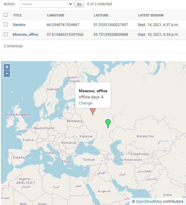
List of objects on the map in the admin panel
To display a map with objects in the site admin panel in the admin settings file admin.py, when registering a model, you need to use the django_admin_geomap.ModelAdmin class.
# admin.py
from django.contrib import admin
from django_admin_geomap import ModelAdmin
from .models import Location

admin.site.register(Location, ModelAdmin)
After making these changes, in the admin panel on the page with a list of Location objects, a map with markers at the locations of these objects will be displayed under the table.
Displaying the object on the map in the edit form in the admin panel
To display an object on the map in the edit/view form, you must additionally specify the field IDs in the Django form, which contain the longitude and latitude values of the object.
For our Location class, the Django admin automatically assigns the IDs id_lon and id_lat to these form fields. The following changes need to be made to the admin.py file.
# admin.py
from django.contrib import admin
from django_admin_geomap import ModelAdmin
from .models import Location

class Admin(ModelAdmin):
    geomap_field_longitude = "id_lon"
    geomap_field_latitude = "id_lat"

admin.site.register(Location, Admin)
After making these changes, in the admin panel on the page for viewing/editing the Location object, a map with a marker at the location of the object will be displayed.
When editing, you can change the position of an object by dragging its icon across the map with the mouse (you need to move the mouse cursor over the bottom of the icon until a blue dot appears on it).
When adding a new object, its position can be set by clicking on the map. Further, the marker of the new object can be dragged, similar to editing.
Additional customization
The library allows you to customize the view of the map and objects by setting special properties for the model class and the django_admin_geomap.ModelAdmin class.
Object icon on the map
The geomap_icon property of the model class sets the path to the marker icon. You can use different icons depending on the state of a particular object.
The default is https://maps.google.com/mapfiles/ms/micons/red.png.
# models.py
from django.db import models
from django_admin_geomap import GeoItem

class Location(models.Model, GeoItem):

    @property
    def geomap_icon(self):
        return self.default_icon
Text in a pop-up panel when you click on a marker on the map
When you click on a marker on the map, a pop-up panel is displayed. The HTML code used in this panel can be set by defining three properties on the model class.
geomap_popup_commondisplayed in regular viewsgeomap_popup_viewdisplayed in the admin panel for a user without permission to edit the objectgeomap_popup_editdisplayed in the admin panel for a user who has permission to edit
By default, all these properties return the string representation of the object.
# models.py
from django.db import models
from django_admin_geomap import GeoItem

class Location(models.Model, GeoItem):

    @property
    def geomap_popup_view(self):
        return "<strong>{}</strong>".format(str(self))

    @property
    def geomap_popup_edit(self):
        return self.geomap_popup_view

    @property
    def geomap_popup_common(self):
        return self.geomap_popup_view
New object icon
The geomap_new_feature_icon property of the django_admin_geomap.ModelAdmin class sets the path to the marker icon when adding a new object in the admin panel.
# admin.py
from django_admin_geomap import ModelAdmin

class Admin(ModelAdmin):
    geomap_new_feature_icon = "/myicon.png"
Default map zoom level and center of the map when displaying a list of objects in the admin panel
You can change the zoom level and position of the center of the map by setting the properties geomap_default_longitude, geomap_default_latitude and geomap_default_zoom in the class django_admin_geomap.ModelAdmin.
By default, the center of the map is located at the point with coordinates "0.0", "0.0" and the scale is "1".
# admin.py
from django_admin_geomap import ModelAdmin

class Admin(ModelAdmin):
    geomap_default_longitude = "95.1849"
    geomap_default_latitude = "64.2637"
    geomap_default_zoom = "3"
Default map zoom level when editing/viewing an object in the admin panel
In object edit form the center of the map coincides with the location of the object. The zoom level of the map can be set by using the geomap_item_zoom property of the django_admin_geomap.ModelAdmin class.
The default is "13".
# admin.py
from django_admin_geomap import ModelAdmin

class Admin(ModelAdmin):
    geomap_item_zoom = "10"
Vertical map size in the admin panel
When displayed, the map occupies the maximum possible horizontal size. The vertical size can be set via the geomap_height property of the django_admin_geomap.ModelAdmin class.
The value must be a string valid in the CSS style definition.
The default is "500px".
# admin.py
from django_admin_geomap import ModelAdmin

class Admin(ModelAdmin):
    geomap_height = "300px"
 vb64
vb64


